Everyone knows rainfall varies from season to season and year to year. Improved understanding of changes in rainfall patterns will help us evaluate the availability of water in rivers and dams, and calculate the amount of water entering into groundwater reserves (aquifers). The project has been working with local partners to combine multiple sources of historical and existing data records to give us more confidence in our understanding of rainfall patterns and variation in Kwale County. We are grateful for the generous support of the Kwale Agricultural Station and the Kenya Meteorological Department for sharing daily rainfall data from recent decades. Preliminary analysis of this data suggests that:
- Annual rainfall has varied between 500 and 1700 mm with a mean annual average of 977 mm
- On average there are 60 days of rain per year – though there have been years with few as 35 days of rain and as many as 100 days
- From 1970 to now, we see no pattern of increase or decrease in annual rainfall or number of rainy days per year
Further analysis is being conducted on other stations.
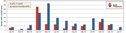
Drought data: Actual and average monthly rainfall at Shimba Hills (1-Jan-16 to 31-Jan-17)
 Long term rainfall data from the KMD rain gauge at Kwale Agricultural Station
Base Titanium’s environmental network records show that rainfall at Shimba Hills Centre was significantly below average in 2016. The long term mean annual rainfall at this site is 1,380mm; 2016 rainfall at this gauge was 739mm, which is 54% of the mean. 2016 was the second driest calendar year on record, the driest year being 1974 (with 693mm, 50% of the long term mean).
