Lessons from the GroFutures Multi-stakeholder Workshops in the Great Ruaha Basin, Tanzania, and Upper Awash Basin, Ethiopia
by John Thompson, Imogen Bellwood-Howard, Gebrehaweria, Gebregziabher, Mohammad Shamsudduha, Richard Taylor, Devotha Kilave, Andrew Tarimo and Japhet Kashaigili
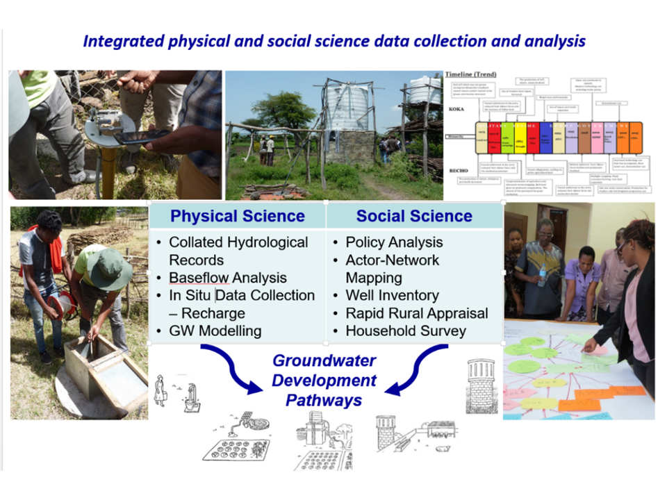
Identifying and characterising groundwater development pathways
More than four years ago, an international group of collaborators embarked on a comparative study of ‘Groundwater Futures in Sub-Saharan Africa’ (GroFutures – http://grofutures.org/) in three ‘basin observatories’, the Great Ruaha in Tanzania, the Upper Awash in Ethiopia, and the Iullummeden in Niger and Nigeria. One key aim of the project was to identify a range of existing, emerging and potential ‘groundwater development pathways’ in each basin.
This work linked interdisciplinary, multi-scale research with a deliberative, multi-stakeholder engagement process in order to inform groundwater planning processes in the basins. Attempts were made to co-locate physical infrastructure to assess groundwater recharge and storage (i.e. piezometer arrays, soil-moisture probes, rain gauges) with key stakeholder communities where the social science was conducted (i.e. household surveys, rapid rural appraisals, well inventories) (Figure 1). The ultimate aim of GroFutures is to generate new evidence and policy relevant insights to open up new pathways towards more sustainable and ‘pro-poor’ groundwater futures in the wider region.
Figure 1. Characterising Groundwater Development Pathway

Six groundwater development pathways by the GroFutures Social Science Team during the course of the research. These ‘stylised’ pathways are representative of broader trends found in the three basin observatories. Each has been characterised in terms of its socio-economic functions; physical dimensions; stage of development; technology; ownership, management and governance arrangements; legal aspects of land and water access; alignment with national policy; and – importantly – its implications for poor water users (a key consideration of the project).
To analyse the longer-term sustainability of groundwater in the basins, the GroFutures Physical Science Team attempted to ‘stress test’ or quantify the impacts of groundwater development pathways, together with the impacts of climate and land-use change, on groundwater recharge and storage in each basin. Employing a groundwater flow model using MODFLOW-2005, run via using the open-source, GIS-based interface (QGIS) that has been developed as part of the newly available FREEWAT platform under a HORIZON 2020 project, the team assessed the hydraulic impacts of pumping under a range of boundary conditions, including variable recharge, over different time scales. These impacts were represented in a set of maps for selected sub-basins in which our social science and physical science teams collected detailed primary hydrogeological and socio-technical data and also drew on relevant secondary information.
A simplified sketch was also prepared to provide a visual representation of each pathway. A key assumption is that these pathways may well co-exist over time and meet the needs of different users. However, there may be cases where there is serious competition and trade-offs between them, leading to positive and negative impacts for different water users and for the environment.
The six pathways and the summary of the modelling ‘stress testing’ for the Great Ruaha and Upper Awash Basins are outlined below. The maps below show the ‘baseline’ groundwater level for each of these, without any pumping. For each pathway, a possible arrangement of wells is suggested, which extract specified volumes at specified depths. The pumping in each pathway gives a new groundwater level, lower than the baseline, projected five years into the future. How much lower depends on the amount of pumping. The new groundwater level for each pathway, can be compared to this baseline. The diagrams and maps presented here come from the pathways described for the Upper Awash. The first five pathways affect the shallow aquifer, while the large-scale commercial agriculture pathway influences the deeper Upper Basaltic Aquifer.
Pathway 1: Small-scale, self-supply for multiple uses

Tanzania: Evident now in this basin
The impact of this pathway on the water table is minimal: groundwater levels fall less than 2 metres over the entire study area with a decline of less than 1 metre over half of the study area. This pumping is not expected to impact the area covered by wetlands or their operation.
Ethiopia: Evident now in this basin
The impact of this pathway on the water table is minimal: groundwater levels fall less than 2 metres over the entire study area with a decline of less than 1 metre over ~70% of the study area. This pumping from shallow wells (<80 m below ground level) is not expected to impact baseflow to streams.
Pathway 2: Small-scale private supply for smallholder intensified agriculture

Tanzania: Not evident yet though promoted in policy
The impact of this pathway on the water table is moderate: groundwater levels decline up to 4 metres over approximately 40% of the study area with declines of less than 3 metres in 60% of the study area. This pumping may locally impact the yields and operation of shallow wells; the impact on wetland extent or operation is not expected to be substantial.
Ethiopia: Evident now in this basin
The impact of this pathway on the water table is moderate: groundwater levels decline 2 – 3 metres over approximately 25% of the study area with declines of less than 2 metres in 65% of the study area. This pumping from shallow wells (<80 m below ground level) may locally impact yields and operation of shallow wells; the impact on baseflow to streams is not expected to be substantial.
Pathway 3: Medium-scale municipal supply for multiple uses

Tanzania: Evident now in this basin
The impact of this pathway on the water table is moderate: groundwater levels decline less than 3 metres over the entire study with declines of less than 2 metres over half of the study area. This pumping may locally impact the yields and operation of shallow wells; the impact on wetland extent or operation is expected to be minimal.
Ethiopia: Evident now in this basin
The impact of this pathway on the water table is moderate: groundwater levels decline less than 3 metres over the entire study with declines of less than 2 metres over 70% of the study area. This pumping from shallow wells (<80 m below ground level) may locally impact the yields and operation of shallow wells; the impact on baseflow to streams is expected to be minimal.
Pathway 4: Medium-scale private supply for commercial agriculture

Tanzania: Not yet evident in this basin
The impact of this pathway on the water table is moderate: groundwater levels fall up to 4 metres in approximately 40% of the study area with declines of less than 3 metres in 60% of the study area. This pumping may locally impact the yields and operation of some shallow wells; the impact on wetland extent or operation is expected to be minimal.
Ethiopia: Evident now in this basin
The impact of this pathway on the water table is substantial: groundwater levels decline between three and five metres over approximately 28% of the study area with declines of less than 3 metres in 60% of the study area. This pumping from shallow wells (<80 m below ground level) is expected to impact yields and operation of some shallow wells as well as baseflow to streams.
Pathway 5: Medium-scale private supply for livestock husbandry

Tanzania: Not yet evident in this basin
The impact of this pathway on the water table is moderate: groundwater levels fall up to 4 metres in approximately 40% of the study area with declines of less than 3 metres in 60% of the study area. This pumping may locally impact the yields and operation of some shallow wells; the impact on wetland extent or operation is expected to be minimal.
Ethiopia: Not yet evident in this basin
The impact of this pathway on the water table is substantial: groundwater levels decline between 3 and 5 metres over approximately 28% of the study area with declines of less than 3 metres in 60% of the study area. This pumping from shallow wells (<80 m below ground level) is expected to impact locally the yields and operation of some shallow wells as well as baseflow to streams.
Pathway 6: Large-scale private supply for commercial agriculture

Tanzania: Not evident yet
The impact of this pathway on the water table is substantial: groundwater levels fall 4 to 6 metres in approximately half of the study area. This intensive pumping of groundwater would impact the yields and operation of shallow wells; intensive pumping would also reduce the supply of water to wetlands impacting the extent and functioning of wetlands and related ecosystem services.
Ethiopia: Evident now in this basin
The impact of this pathway on the water table is very substantial: groundwater levels decline by more than 5 metres over approximately 27% of the study area with declines of 3 – 5 metres over 55% of the study area. This intensive, dry-season pumping of groundwater from deep wells (180 to 300 m below ground level) would impact the yields and operation of deep wells.
Analysing the Stress-Tested Pathways
In June and July 2019, colleagues from Institute of Development Studies (IDS) and the ESRC STEPS Centre, the International Water Management Institute (IWMI) and University College London (UCL), in collaboration with partners at Sokoine University of Agriculture (SUA) and Addis Ababa University (AAU), hosted two multi-stakeholder workshops at which the groundwater development pathways were assessed using Multicriteria Mapping (MCM) (Figure 2).
Figure 2. Participants at the GroFutures Multi-stakeholder Workshops in Tanzania and Ethiopia

MCM is multi-stage interview and engagement approach which helps stakeholders to explain their views and priorities in a structured and systematic way without necessarily identifying a single ‘best’ decision but to highlight underlying criteria that influence people’s perceptions of different options or pathways. The GroFutures team used MCM software developed by the University of Sussex and STEPS Centre with stakeholders representing a range of actor groups from local to basin to national levels with knowledge and interest in groundwater development and management.
In both workshops, the GroFutures team trained a group of Research Assistants recruited through SUA and AAU to serve as MCM facilitators in the workshops. The invited participants represented a range of stakeholder groups – e.g. local domestic water users; local irrigators; district agricultural and water officials; NGO representatives; national agriculture and water officials; private sector representatives; livestock sector representatives (Tanzania). This allowed the team to cluster them into specific interest groups. Each group was assigned one facilitator to assist them in reviewing the six ‘stress-tested’ pathways and analysing them against a core set of criteria provided by the GroFutures Team – i.e. equitable access; environmental sustainability; and ease of operation and maintenance – as well as their own specific criteria.
The groups spent the afternoon of the first day of the workshop defining their criteria and then used the morning of the second day to scoring the pathways against the core criteria and their own additions. For each criterion and pathway, an ‘optimistic’ and ‘pessimistic’ score was given on a scale of 0 (low) to 100 (high). The facilitators encouraged the participants to explain why they used each criterion and scored each pathway as they did.
This information was captured in the MCM software so that we had a clear description of the decision-making behind the scoring. After they completed the scoring, participants were invited to weight their criteria from most to least important, to add further insights into their preferences.
After all participants have done this, the researchers can combine the data from each participant and analyse the whole data set to understand similarities and differences between groups.

